Biography written by Katie Davis
Marie Catherine and Elizabeth Haussard were French engravers known for their beautiful engravings on geographical maps and natural history plates. Little is known about the lives of the sisters, and much of their work has been lost or misattributed due to the difficulty of publishing as a woman in the eighteenth century. There are still many beautiful cartouches, however, that can be definitively accredited to the Haussard sisters. They worked on a variety of maps, many of which were included in the famous French Atlas Universel (1757). From their home in Paris along the Rue du Platre, Marie Catherine and Elizabeth produced engravings that graced map cartouches for North America, South America, Egypt, Belgium, and Lorraine.
Little is known about Marie Catherine and Elizabeth Haussard’s childhoods. Based on contextual evidence, including the birth dates of their contemporaries, the two sisters were born approximately at the turn of the eighteenth century. Marie Catherine and Elizabeth were the daughters of notable Parisian engraver Jean-Baptiste Haussard (1679-1749). Jean-Baptiste was best known for his works in the Recueil Ferriol (1714), a collection of illustrations created as part of the European effort to distinguish ethnic groups in the Ottoman Empire at the beginning of the eighteenth century. He was responsible for executing fifteen total engravings in the Recueil Ferriol, including famous works such as Turkish Girl at the Bath and Armenian Girl Going to be Married. Marie Catherine and Elizabeth learned engraving from their father before producing their own works, including map legends, labels, and decorative map cartouches. The sisters also engraved natural history plates and scientific works.
Cartography exploded in Europe during the seventeenth and eighteenth centuries. Women were heavily involved in mapmaking, although most only learned through indirect means, such as from their husbands or fathers. The Haussard sisters, like many other women in the field, including Mary Ann Rocque, used their initials instead of their names to sign their works. While doing so allowed them to conceal their gender, this same tactic makes it difficult to recognize their works today. Notably, there is evidence that both sisters, while doing contract work for the Comite de Librairie of the Academie Royale des Sciences, petitioned for greater compensation for their work: “We have engraved the plates for the volumes of the Savants Etrangers for many years, but that is becoming more and more difficult.”[1]
The Haussard sisters are best known for their work for the de Vaugondy family of cartographers. Marie Catherine and Elizabeth signed nearly one third of the cartouches in the famous Atlas Universel, a collection of 108 maps by Gilles and Didier Robert de Vaugondy and the first atlas sold in France by subscription. With estimates of subscribers ranging from six hundred to one thousand, the Atlas was one of the most acclaimed works of its time, supporting Vaugondy’s appointment as Geographe Ordinaire du Roi. Among the subscribers was Jeanne Antoinette Poisson, Marquise de Pompadour, indicating its patronage by the royal court.
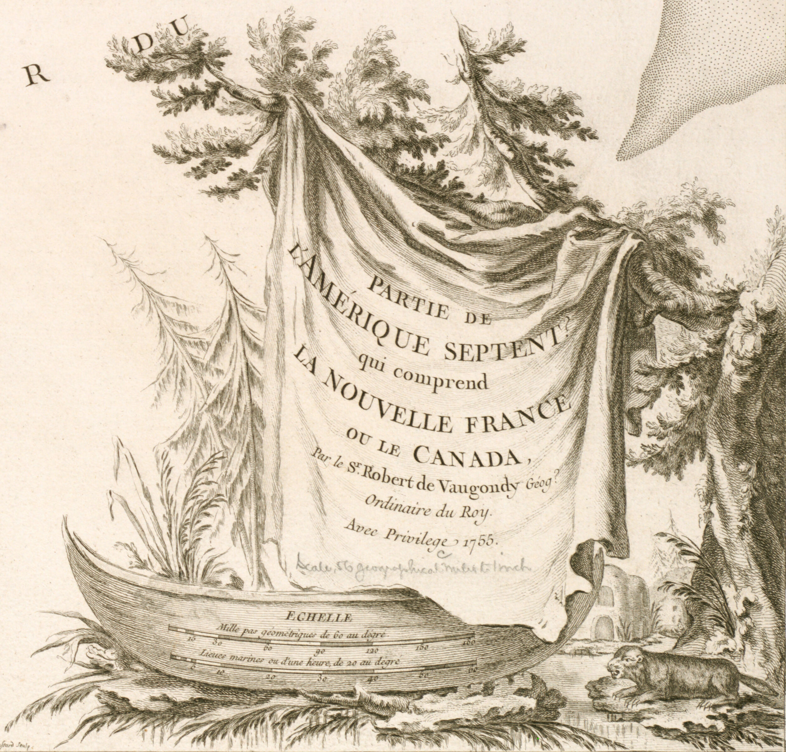
A few of the maps in the Atlas engraved by the Haussard sisters stand out. In the Partie de l'Amérique Septent. Qui Comprend la Nouvelle France ou le Canada (Part of North America Which Includes New France and Canada), Marie Catherine’s signature, “C. Haussard,” is discernible in the detail of the map. The striking cartouche includes popular symbols of the North American wilderness and voyageur lifestyle in the Great Lakes region of New France: pine trees, a beaver, and a canoe. Another of Marie Catherine’s works in the Atlas is the Partie de l'Amérique Septentrionale Qui Comprend le Cours de l'Ohio, la Nlle Angleterre, la Nlle York, le New Jersey, la Pensylvanie, le Maryland, la Virginie, la Caroline (Part of North America Which Comprises of the Ohio River, New England, New York, New Jersey, Pennsylvania, Maryland, Virginia, Carolina). She is identified by the line “M.C. Haussard,” although she likely etched the detail into the design rather than incised it. The map covers the area from the Great Lakes to South Carolina and from the Atlantic Coast to the Mississippi River, whilst depicting provinces, counties, settlements, rivers, Native American territories, and forts. Elizabeth Haussard, the younger of the two sisters, also has notable works in the Atlas attributed to her. The Carte de la Virginie et du Maryland (Map of Virginia and Maryland), a French edition of the the Fry-Jefferson Map, was issued in the Atlas Universel although two versions, or states, of the map exist. The first is dated to 1755 and the plate is signed “E Haussard,” presumably indicating the original was engraved by Elizabeth. The name E. Haussard was deleted in a later state of the Fry-Jefferson Map and from 1778 onward was replaced by the name “Groux,” probably engraver Charles Jacques Groux, although the confirmed identity of “Groux” and why he signed the cartouches is a mystery. The only previous map of Virginia associated with a woman was the Farrer map of 1651.
The sisters’ dates of death are unknown. In fact, many important details about the lives of the sisters escape us today due to their strategic use of initials rather than full signatures on their work. Despite these obfuscations, however, they remain an important part of the cartographic institution of the eighteenth century.