Biography written by James Huebner
Charles Blaskowitz was one of the British military’s most accomplished surveyors during the American Revolutionary War. Prior to the Revolution, he worked with other talented British cartographers to help survey key areas of colonial Canada. When the Revolutionary War broke out, Blaskowitz worked on campaign maps for General William Howe and a siege plan for Newport, Rhode Island.
Blaskowitz was born in the Kingdom of Prussia in 1743. The region of his birth was very likely Silesia, which rests in present-day Poland; as such, he has also been identified as Polish by birth. During his teenage years, Blaskowitz immigrated to London to receive training at the Drawing Room of the Tower of London, the British government’s institution for mapmaking for the army. Around this time, Blaskowitz himself joined the British army. When he was eighteen, Blaskowitz travelled to the Americas to take part in the creation of the Murray Map. Working in coordination with fellow British military surveyor James Murray, Blaskowitz assisted in mapping the St. Lawrence Valley. Published in 1761, the map was the first of Blaskowitz’s career. In 1765, Blaskowitz again worked with Murray on a map of Lake Champlain, which charted the demarcation line between New York and Quebec.
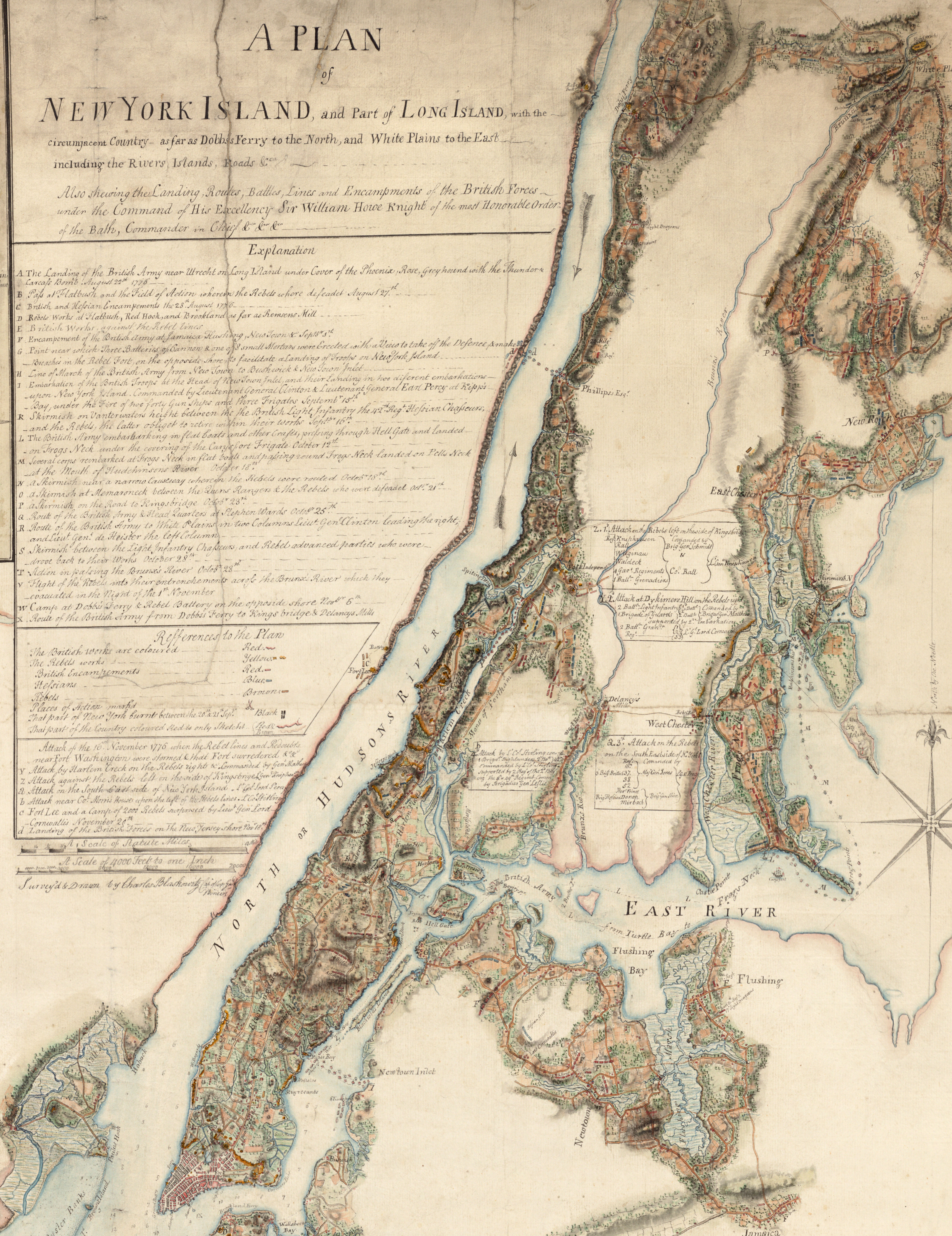
The best-known works of Blaskowitz’s career were made in the period between 1775 and 1777. In 1776, he surveyed and created the two primary maps for General William Howe’s campaign in New York, marking the tremendous rise of the 33-year-old surveyor. Each of the maps took up almost an entire wall, showing the landscape in the intimate detail that the campaign required. The following year, Blaskowitz served in Rhode Island, where he created his most recognizable work. Published on September 1, 1777, The Plan for the Town of New Port Rhode Island depicts the fortified town of Newport, which was a target of the British navy. The map shows the fortifications of the town as well as the locations of important buildings and key infrastructure. One of these buildings was the Touro Synagogue, then the oldest synagogue building in British North America and the oldest surviving synagogue in the United States today, where George Washington would famously visit years later as president.
After the war ended, Blaskowitz returned to Britain, where he died in Lambeth in 1823. In 1939, the Polish artist Arthur Szyk featured Blaskowitz in an art exhibition at the New York World’s Fair titled, Pictures from the Glorious Days of The Polish American Fraternity. In the painting of Blaskowitz, he is seen working on his map of Newport.