Biography written by Brennan Owens
Michel Capitaine Du Chesnoy was a French military officer and geographical engineer who served as aide-de-camp to General Marquis de Lafayette during his service in the American Revolutionary War. As part of his duties, Capitaine created a series of manuscript maps of strategically important sites related to Lafayette’s battles. His maps include some of the most exact battlefield details of the war.
In June 1777, at the age of 31, Capitaine arrived in South Carolina with the nineteen-year-old Marquis de Lafayette. The cartographer was soon struck by illness and would spend time recuperating for almost a year until the spring of 1778. During his time recovering, Capitaine produced one of his first and most consequential maps of the Revolutionary War: a survey of the British positions at Ticonderoga, Plan of Carillon or Ticonderoga. ![detail from Captiaine du Chesnoy's 1777 map "Plan of Carillon ou [sic] Ticonderoga"](https://iiif.digitalcommonwealth.org/iiif/2/commonwealth:q524nk513/77,4128,2990,2000/full/0/default.jpg) The map is unique, as Capitaine created the battlefield map through a combination of reconnaissance accounts and secondary maps without visiting the area. When the British occupied Fort Ticonderoga in October 1777, Lafayette was in Pennsylvania and Capitaine was in North Carolina. Unlike many of Capitaine’s maps, the map’s legend is largely in English, as the English-speaking Americans fighting at Saratoga were its primary audience.
The map is unique, as Capitaine created the battlefield map through a combination of reconnaissance accounts and secondary maps without visiting the area. When the British occupied Fort Ticonderoga in October 1777, Lafayette was in Pennsylvania and Capitaine was in North Carolina. Unlike many of Capitaine’s maps, the map’s legend is largely in English, as the English-speaking Americans fighting at Saratoga were its primary audience.
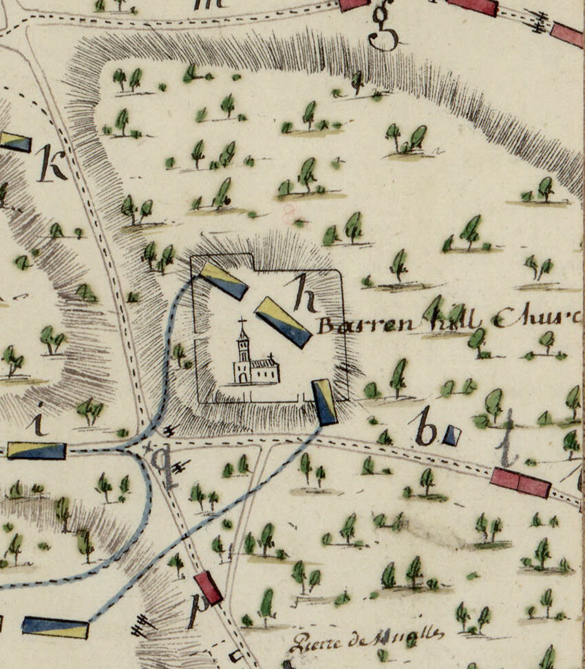
In April 1778, Capitaine traveled north towards the main theater of war. Congress appointed him a captain in the Continental Corps of Engineers and assigned him to map the Susquehanna River. Lafayette was frustrated that his personal cartographer was not by his side for months as Capitaine was an invaluable part of the general’s camp. Lafayette wrote to Henry Laurens, president of the Continental Congress, about Capitaine’s assignment to chart the Susquehanna River, stating that he was “glad he is employed if no other can do the business” but that Capitaine should “be considered as mine.”[1] By May 1778, Capitaine rejoined Lafayette’s camp at Barren Hill near Philadelphia, where Lafayette was confronted with a massive number of British troops from the city who attempted to capture the hill. Capitaine depicted Lafayette’s masterful retreat in Plan de la Retraite de Barren Hill en Pensilvanie. The map portrays the positions of American, British, and Hessian soldiers as the British started their assault on the hill, and highlights important battlefield details such as roads, terrain, and troop deployments.
For the remainder of his service in the Revolutionary War, Capitaine traveled freely alongside Lafayette. He mapped the Battle of Monmouth in Carte de l'Affaire de Montmouth le 28 Juin 1778 entre Clinton et Washington. Capitaine carefully drew the terrain of deep ravines that would prove decisive in waging the battle along the several positions taken by the British and American armies. The twenty-four-item legend gives additional detailed notes on the action of the day. Capitaine received praise after sending the Monmouth and other maps to George Washington, who described them as “executed with great accuracy and military intelligence—and will have a place among the papers on which I set a value.” [2]
In January 1779, Capitaine followed Lafayette to France, and played a pivotal role in representing the American revolutionary struggle to the French Court. As Lafayette said of Capitaine, “Such an officer I can’t spare, and I will employ him to make plans of our positions and battle for Washington, for me, and also for the king who will be glad to have an exact draft of Washington’s battles.”[3] Capitaine brought his map, Carte du Théatre de la Guerre dans l'Amérique Septentrionale, Pendant les Années 1775, 76, 77, et 78, which was uncharacteristic of his work in depicting a large strategic overview of the Revolutionary War. The purpose was to provide King Louis XVI a picture of the broader continental struggle, and it succeeded in helping to reinforce France’s support for the United States.
In the spring of 1780, Capitaine returned to North America with Lafayette and mapped the general’s final battles in the Revolutionary War. Capitane’s last map of the war, Plan d'Une Partie de la Virginia, provides an ambitious picture of both the strategy and tactics of the Virginia campaign of 1781. The map documents elements that were critical to the outcome of the Battle of Yorktown, including troop disposition and movement, terrain and locations of camps and batteries.
Following the battle, Capitaine again returned to France with Lafayette. Although the cartographer never returned to America, he retained his Continental Army rank of major until November 1783 and remained a lifetime member of the Society of the Cincinnati. Capitaine served as an assistant on the French army general staff until 1790.He died in France in 1804.